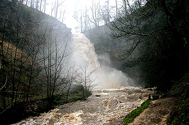
HARDRAW FORCE
England's Highest Single Drop Waterfall
The Geological History of Hardraw Force
It all started about 340 million years ago, during the Middle Carboniferous period. To be precise it was between 345.3 and
320 million years ago during the Visean stage and just entering the Namurian stage.
Alternating layers of limestone, shale and
sandstone, along with some thin coal
and earth seams were laid down. The sequence was
repeated about eight times.
This, plus some glacial activity as well, lead to the spectacular geologically unique Karst scenery of the
Yorkshire Dales that we see today.
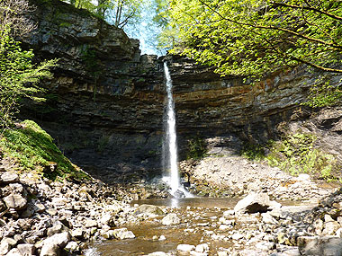
It is known as the Yoredale Series. The layered structure of the Yoredale Series in particular is conducive to the formation of fine waterfalls such as Hardraw Force and Aysgarth Falls in Wensleydale (along with many others) as the water flows over the edges of the exposed limestone beds. It also produces the "stepped" effect that can be seen on the valley sides. The limestone formations of Wensleydale are: Hawes limestone, Gayle limestone, Hardrow Scaur limestone, Simonstone limestone, Middle limestone, Five Yard limestone, Three Yard limestone, Underset limestone and Main limestone.
In Wensleydale the Yoredale Series group sits on top of the Great Scar group. At the back of the water fall it is possible to see these layers of limestone, sandstone and shale.
Hardraw Force flows over the edge of the Hardrow Scaur limestone formation.
How it all happened...
The layers were laid down in warm seas and river deltas. This area was once covered in warm seas and river deltas which changed in depth. The alternation of these layers was be due to these changes in water depth.
The primary source of limestone is most commonly marine organisms. Some of these organisms can construct mounds of rock known as reefs, building upon past generations. The limestone was formed in the shallow seas under 3000m deep.
Silts deposited in deeper water later became shale.
The advance of the shoreline southwards meant that the silts were covered by sandy deposits which later became sandstone.
Thin coal seams topping the sandstones are evidence of the swamp vegetation which developed here, while some of these layers were covered by soil in places which is thought to have formed on dry land. So the land was rising and falling over this time, causing these different layers to be deposited. Sometimes in deep water, sometimes shallow and sometimes out of the water.
It is suggested that these layers were formed by flows deep within the molten material of the earth’s mantle, causing uplifting in some areas and sinking in others.
Also the changing shape of the delta, and the changing course of the channels flowing across it caused great variation in the depth of water, and this accounts in part for the nature, extent and thickness of the sediment layers.